What groundwater is
Underground water found in rock formations and soil is known as groundwater. It is stored in cracks and spaces in the geological formations and can be accessed through bores drilled into those formations. The formations that yield water in this way are called aquifers.
The water level or pressure in an aquifer determines the height that water will rise above the ground. In most cases, the water level is below the surface and requires pumping. In rare instances, such as in parts of the Great Artesian Basin in Queensland, the groundwater pressure is above the surface (known as artesian water), causing the water to naturally rise without the need for pumping.
Groundwater moves slowly in response to changes in groundwater levels or pressure. When water is taken from a bore, the water level in the surrounding area declines. The decline in water level gradually reduces with distance from the bore.
The amount by which the water level drops is known as the drawdown and the extent of drawdown depends on both the formation's permeability (a rock property that determines how easily water can flow through it) and its ability to store water under pressure.
The impact of resource operations on groundwater
Groundwater is mainly accessed as a source of water supply for domestic and agricultural use. Sometimes it is extracted to reduce pressure in rock formations for the extraction of natural gas such as CSG, and minerals such as coal. This process is called depressurisation and the extracted groundwater is called associated water.
In the process of extracting oil and gas, some groundwater may also be extracted. This may directly or indirectly impact surrounding aquifers, reducing the availability of groundwater if it flows or leaks into the coal formation. Water can also move between aquifers if they are connected by permeable rock, fractures or geological faults.
Impacts on aquifers from resource development are predicted primarily by building mathematical models using computers (i.e. groundwater flow models). These models are informed by the best available conceptualisation and data on connectivity, determined through investigations and research.
OGIA has developed a complex regional-scale groundwater flow model to predict impacts from current and planned resource development in the Surat Cumulative Management Area. Impact predictions are revised every 3 years and reported in the Underground Water Impact Report (UWIR).
Groundwater impacts from coal seam gas (CSG) development
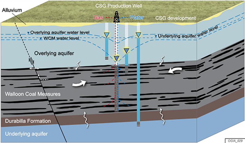
CSG is a natural gas held within the coal formations by groundwater pressure. A well (similar to a water bore) is drilled to depressurise the coal formation by extracting groundwater. As the pressure is reduced, the gas is gradually released together with groundwater. There is more water than gas in the initial period but over time, the proportion of water gradually declines to being practically negligible and only gas is produced.
The impact of depressurisation from groundwater removal spreads in all directions from the site of extraction. It also creates a pressure difference between the target formations and those above and below, as illustrated in this diagram. This pressure difference encourages groundwater to flow towards the site of extraction and potentially impacts the availability of groundwater at the source.
In Queensland's Surat Basin CSG fields, many wells are placed approximately 700 to 1,000 metres apart to depressurise large areas of CSG reservoirs and maximise gas extraction. This also creates potentially widespread and cumulative impacts from groundwater extraction that must be assessed and managed.
Transcript
[Voiceover]
This video presents how groundwater impacts may occur in aquifers surrounding the coal seam gas formations in the Surat Basin in Queensland, Australia.
Similar to the way water in rivers and streams moves from higher to lower elevations, groundwater in porous formations – or aquifers – moves from high pressure to lower pressure. The pressure difference drives the way water moves, both within and between aquifers.
Groundwater in deeper aquifers of the Surat Basin is under pressure. For this reason, when a water bore is drilled, water rises to a level somewhere above the aquifer. The level it rises to is called the bore water level, also referred to as the groundwater level in the aquifer.
In the Surat Basin, within the CSG development area, the top of the Walloon Coal Measures is 200 to 800 metres below ground, but the water level is generally about 50 metres deep. Water levels in the Springbok and the Hutton sandstones – the aquifers above and below this coal formation – are generally about 30 metres below ground.
Gas is extracted by drilling a well into the coal formation and pumping groundwater out of the well to lower pressure, which in turn releases the gas. As the CSG development proceeds, water pressure in the coal formation continues to fall. This creates a pressure difference between the coal formation and the surrounding aquifers. Depending on how permeable the intervening formations are, water can move from those aquifers into the coal formation, lowering the water level in the aquifers. This is how groundwater is impacted.
Impacts on aquifers are predicted using a tool called a groundwater flow model. Models are built from available information and studies about groundwater flows and connectivity. The Office of Groundwater Impact Assessment has developed a regional-scale groundwater flow model to predict impacts from current and planned CSG development in the Surat Cumulative Management Area. Impact predictions are revised every 3 years and reported in the Underground Water Impact Report.
In the short term, impacts are predicted as the Immediately Affected Area, or IAA, which is the area of an aquifer where more than 5 metres of decline is predicted within the next 3 years. Shown here as a red line for the Walloon Coal Measures. The Long-term Affected Area, or LAA, is the area where more than 5 metres of decline is predicted to occur at any time in the future. The Walloon Coal Measures has the greatest predicted impacts in the Surat Basin, with declines of more than 500 metres predicted.
The Springbok Sandstone, which directly overlies the Walloon Coal Measures, is predicted to have water level declines around active CSG fields by generally about 20 to 50 metres.
The Hutton Sandstone, which is the aquifer below the Walloon Coal Measures, is only predicted to be affected in the south-eastern part by generally about 10 metres.
In the Condamine Alluvium, which sits directly above the Walloon Coal Measures, the predicted impact is less than 0.2 metres across most of the area.
There are some springs and watercourses that are predicted to be impacted in the northern parts of the CSG production areas, but the impacts are generally less than a metre.
For more information about this video, or if you have questions about the Underground Water Impact Report, visit our website.
Groundwater impacts from coal mining
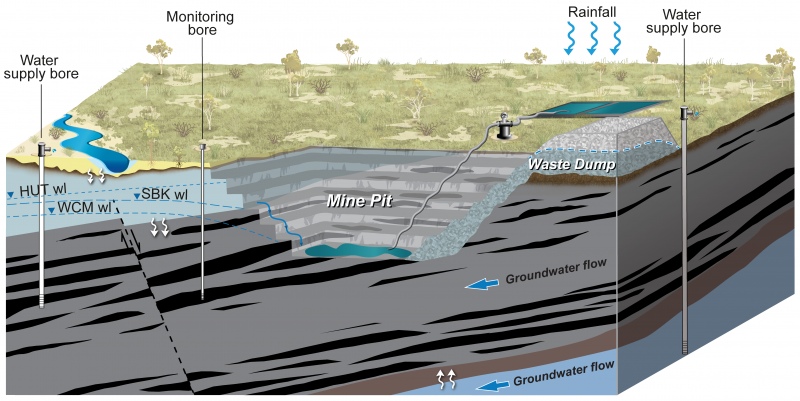
Coal is extracted using either open-cut or underground (longwall) mining methods. The coal mines in the Surat Basin are all open cut, as illustrated in the diagram. The excavation of coal results in a mine pit exposing coal seams that intersect with the water table. This causes groundwater to seep or inflow into the pits, decreasing the groundwater in areas near the mine. For safe operation of the mine, the water is pumped out and discharged away from the pit. This process is called dewatering.
In the Surat Basin coal mines, the drop generally extends to about 5 kilometres.
If the volume of water flowing into the pit is very high, water bores may be drilled around the mine pit to aid dewatering. In the Surat Basin this type of depressurisation is not required because pit inflows are very low in volume.
Reduction in water level can also cause some loss of groundwater from aquifers above and below the coal seams. Geological faults, if present, may provide additional pathways or barriers for the impacts of coal mining to spread.
This video shows impacts from coal mining on groundwater and how impacts can be predicted.
Transcript
[Voiceover]
This video presents how groundwater levels may be impacted by coal mining in the Surat Basin.
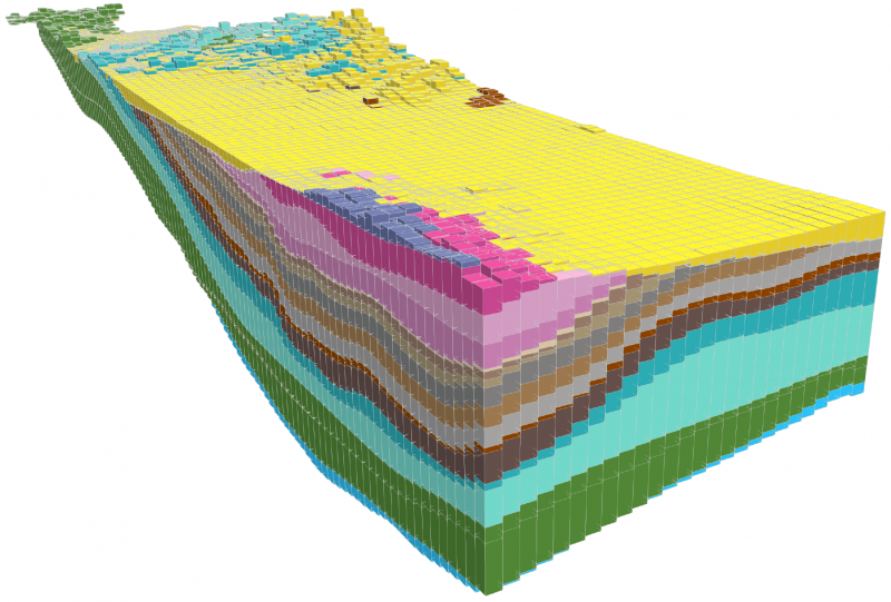
The major formations of the Surat Basin are shown here as different colours, together with the Condamine Alluvium that sits on top.
Coal mines are located within the Surat Basin, where coal extraction is targeted from the Walloon Coal Measures. It’s the same formation from which coal seam gas is extracted.
There are eight existing and proposed coal mines. In the northern part of the basin, three mines are proposed – Elimatta, the Range, and Wandoan coal mine.
In the central area, two mines are in operation – Cameby Downs and Kogan Creek. A third mine, Wilkie Creek, is now closed. Further to the east is the New Acland mine, where expansion is proposed; the Commodore mine is towards the south.
All existing and proposed coal mines in the Surat Basin are open-cut.
The mine pit is progressively developed, starting from where coal is accessible at shallow depth and then moving to deeper parts, creating several benches. In some instances, the overlying Springbok Sandstone or thin alluvial cover is also stripped off, in order to access deeper coal.
In the Surat Basin, mine pits are generally less than 100 metres deep. Groundwater below the water table seeps into the pit. For safe operation of the mine, the water is pumped out and discharged away from the pit. This causes the water level in the coal formation adjacent to the pit to drop to the base of the pit. Away from the pit, the drop is progressively less and generally extends to about 5 kilometres.
Drops in water level also induce some loss of groundwater from the overlying and underlying formations. Geological faults, if present, may provide additional pathway or barrier for impacts.
At the end of mining operations, parts of the pit are backfilled from the waste rock to above the water table, leaving a small final sump. Groundwater levels slowly recover to below the final sump. If the sump is below the water table then water can accumulate in the final sump and can be lost to evaporation.
Impacts are predicted using a tool called a groundwater flow model. Models are built from available information and studies about groundwater flows and connectivity.
The Office of Groundwater Impact Assessment has developed a regional-scale groundwater flow model to predict impacts from current and planned coal seam gas development and coal mining. This is the first time that coal mining impacts are included in the cumulative assessment.
The predictions of coal mining impacts rely on information about existing pits, planned development footprints and sequencing of mine pits.
As an example, Cameby Downs mine near Chinchilla commenced operations in 2009 and progressed southwest. The Office of Groundwater Impact Assessment has compiled similar information for all mines in the Surat Basin for all previous and future years.
In most cases, coal seam gas development precedes coal mining; as a result, additional impacts from coal mining are a relatively very minor proportion of the overall cumulative impacts from resource development. Predictions of impacts are available in the Underground Water Impact Report.
For more information about this video, or if you have questions about the Underground Water Impact Report, visit our website.
Watch the Groundwater impact from coal mining video.
Assessment and modelling of groundwater impacts
A combination of field studies including monitoring, mapping, sampling and remote-sensing techniques are used to gather information on geology and groundwater movement, groundwater levels, water quality, flow rates and information on resource development operations. This data is used to assess and model groundwater impacts from CSG and mining development.
Impacts are predicted using groundwater flow models. These are mathematical representations of groundwater systems based on the physical features of the subsurface, such as the permeability of the rock and soil, the depth and thickness of the aquifers and the distribution of recharge and discharge zones. Recharge occurs when groundwater enters the groundwater system, such as through flooding or rainfall. Discharge occurs when groundwater leaves the system, such as through springs. This diagram is a visual representation of this type of model.
Data gathered through monitoring is used to calibrate model parameters (calibration). This works by refining parameters to only include values that are able to consistently match historical observations, reducing the uncertainty in model predictions.
A groundwater model predicts changes to groundwater pressure around the resource development areas, as a result of groundwater being extracted during CSG and coal mining.
Monitoring of groundwater impacts
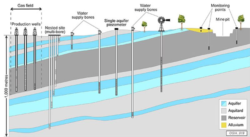
Groundwater impacts are directly or indirectly monitored by measuring the levels and quality of groundwater in specially constructed bores called monitoring bores. Geological material encountered when drilling monitoring bores, and water level and water quality measurements taken over a period of time, are used to assess groundwater resources and track changes.
This diagram shows the various types and depths of monitoring bores used in the Surat CMA including nested multi-bore sites, single-aquifer piezometers and monitoring points adjacent to mine pits.
The impact of resource development on observed groundwater levels is difficult to measure directly. This is because monitoring data is affected by a variety of factors, not all of which relate to resource development including climatic factors and groundwater extraction for water supply. Scientific methods are required to assess the monitoring data to separate the impacts of resource development from other sources of influence.
Management of groundwater impacts
Queensland has an innovative and proactive framework for managing groundwater impacts from resource development. It involves independent and periodic cumulative assessment, monitoring and complementary regulatory tools. The tools aim to minimise and mitigate the impacts on groundwater-dependent ecosystems and to make good any impairment of affected water supply bores.
The management framework provides for clear responsibilities of tenure holders to:
- undertake baseline assessments of water bores
- prepare baseline assessment plans
- implement make good arrangements for water bores
- prepare underground water impact reports (UWIRs).
Last updated: 31 Oct 2023