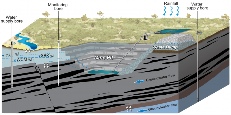
Coal is extracted using either open-cut or underground (longwall) mining methods. The coal mines in the Surat Basin are all open cut, as illustrated in the diagram. The excavation of coal results in a mine pit exposing coal seams that intersect with the water table. This causes groundwater to seep or inflow into the pits, decreasing the groundwater in areas near the mine. For safe operation of the mine, the water is pumped out and discharged away from the pit. This process is called dewatering.
In the Surat Basin coal mines, the drop generally extends to about 5 kilometres.
If the volume of water flowing into the pit is very high, water bores may be drilled around the mine pit to aid dewatering. In the Surat Basin this type of depressurisation is not required because pit inflows are very low in volume.
Reduction in water level can also cause some loss of groundwater from aquifers above and below the coal seams. Geological faults, if present, may provide additional pathways or barriers for the impacts of coal mining to spread.
This video shows impacts from coal mining on groundwater and how impacts can be predicted.
Transcript
[Voiceover]
This video presents how groundwater levels may be impacted by coal mining in the Surat Basin.
The major formations of the Surat Basin are shown here as different colours, together with the Condamine Alluvium that sits on top.
Coal mines are located within the Surat Basin, where coal extraction is targeted from the Walloon Coal Measures. It’s the same formation from which coal seam gas is extracted.
There are eight existing and proposed coal mines. In the northern part of the basin, three mines are proposed – Elimatta, the Range, and Wandoan coal mine.
In the central area, two mines are in operation – Cameby Downs and Kogan Creek. A third mine, Wilkie Creek, is now closed. Further to the east is the New Acland mine, where expansion is proposed; the Commodore mine is towards the south.
All existing and proposed coal mines in the Surat Basin are open-cut.
The mine pit is progressively developed, starting from where coal is accessible at shallow depth and then moving to deeper parts, creating several benches. In some instances, the overlying Springbok Sandstone or thin alluvial cover is also stripped off, in order to access deeper coal.
In the Surat Basin, mine pits are generally less than 100 metres deep. Groundwater below the water table seeps into the pit. For safe operation of the mine, the water is pumped out and discharged away from the pit. This causes the water level in the coal formation adjacent to the pit to drop to the base of the pit. Away from the pit, the drop is progressively less and generally extends to about 5 kilometres.
Drops in water level also induce some loss of groundwater from the overlying and underlying formations. Geological faults, if present, may provide additional pathway or barrier for impacts.
At the end of mining operations, parts of the pit are backfilled from the waste rock to above the water table, leaving a small final sump. Groundwater levels slowly recover to below the final sump. If the sump is below the water table then water can accumulate in the final sump and can be lost to evaporation.
Impacts are predicted using a tool called a groundwater flow model. Models are built from available information and studies about groundwater flows and connectivity.
The Office of Groundwater Impact Assessment has developed a regional-scale groundwater flow model to predict impacts from current and planned coal seam gas development and coal mining. This is the first time that coal mining impacts are included in the cumulative assessment.
The predictions of coal mining impacts rely on information about existing pits, planned development footprints and sequencing of mine pits.
As an example, Cameby Downs mine near Chinchilla commenced operations in 2009 and progressed southwest. The Office of Groundwater Impact Assessment has compiled similar information for all mines in the Surat Basin for all previous and future years.
In most cases, coal seam gas development precedes coal mining; as a result, additional impacts from coal mining are a relatively very minor proportion of the overall cumulative impacts from resource development. Predictions of impacts are available in the Underground Water Impact Report.
For more information about this video, or if you have questions about the Underground Water Impact Report, visit our website.
Watch the Groundwater impact from coal mining video.
Last updated: 31 Oct 2023